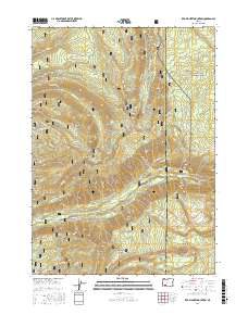
2017 Map of Red Blanket Mountain
USGS Topo · Published 2017About this map
Crater Lake National Park occupies the northeastern edge of this mountain study, where the boundary with Rogue River National Forest meets the line between Jackson and Klamath counties. The landscape is defined by a dense network of timber-access routes, such as Red Blanket Rd and Gingko Rd, which navigate the high-elevation drainages of Red Blanket Cr and Mill Cr. High points including Red Blanket Mountain and Cinnamon Peak anchor the southern and central terrain, while Huckleberry Mtn rises near the northern forest boundary. The nomenclature of the area preserves local lore through names like Dead Soldier Meadow and Lookout Gulch, offering a glimpse into the management and naming of these Cascade Range foothills in the modern era.
Find a feature on this map
46 named features on this map. Tap any name to fly to it.
Don’t see what you’re looking for? This feature index may not catch every label — zoom into the map to look around manually.
Map Details
Editions of this 2017 Red Blanket Mountain Map
This is the sole edition of this map. No revisions or reprints were ever made.
Other maps of this area

1891 · Ashland
USGS Topo · 1:250,000

1893 · Ashland
USGS Topo · 1:250,000

1897 · Ashland
USGS Topo · 1:250,000

1955 · Rustler Peak
USGS Topo · 1:62,500

1955 · Pelican Butte
USGS Topo · 1:62,500

1955 · Medford
USGS Topo · 1:250,000

1956 · Prospect
USGS Topo · 1:62,500

1957 · Medford
USGS Topo · 1:250,000

1958 · Medford
USGS Topo · 1:250,000
1975 · Prospect 1 NW
USGS Topo · 1:24,000