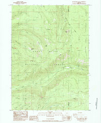
1985 Map of Red Blanket Mountain
USGS Topo · Published 1985About this map
The boundary between Jackson Co and Klamath Co bisects this mountainous landscape where the Rogue River National Forest meets Crater Lake National Park. The topography is defined by prominent peaks including Red Blanket Mtn, Cinnamon Peak, and Huckleberry Mtn, with a dense network of drainages such as Union Creek and Red Blanket Creek carving through the terrain. A variety of high-country landmarks are documented, from the secluded Dead Soldier Meadow and Varmint Camp to essential water sources like Alder Spring and Cold Spring. This provisional survey preserves the state of the backcountry in the mid-1980s, noting practical features like the Bessie Shelter and several resource extraction sites such as a Borrow Pit and Gravel Pit near the headwaters of Gyppo Creek.
Find a feature on this map
31 named features on this map. Tap any name to fly to it.
Don’t see what you’re looking for? This feature index may not catch every label — zoom into the map to look around manually.
Map Details
Editions of this 1985 Red Blanket Mountain Map
This is the sole edition of this map. No revisions or reprints were ever made.
Other maps of this area

1891 · Ashland
USGS Topo · 1:250,000

1893 · Ashland
USGS Topo · 1:250,000

1897 · Ashland
USGS Topo · 1:250,000

1955 · Rustler Peak
USGS Topo · 1:62,500

1955 · Pelican Butte
USGS Topo · 1:62,500

1955 · Medford
USGS Topo · 1:250,000

1956 · Prospect
USGS Topo · 1:62,500

1957 · Medford
USGS Topo · 1:250,000

1958 · Medford
USGS Topo · 1:250,000
1975 · Prospect 1 NW
USGS Topo · 1:24,000