
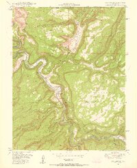
1949 Map of Red Canyon
USGS Topo · Published 1955About this map
Mining operations and high mesas dominate this 1949 topographic survey of the Colorado backcountry, conducted in collaboration with the United States Atomic Energy Commission. The canyon landscape is defined by the convergence of the San Miguel River and the Dolores River, where several Placer Mines once operated along the riverbanks. Higher elevation terrain like Blue Mesa, Martin Mesa, and Atkinson Mesa surround the deep incisions of Red Canyon and Moon Canyon.
Find a feature on this map
34 named features on this map. Tap any name to fly to it.
Don’t see what you’re looking for? This feature index may not catch every label — zoom into the map to look around manually.
Map Details
Editions of this 1949 Red Canyon Map
2 editions found
Historical Maps of Mesa County Through Time
226 maps found

1916 Paradox Valley
Montrose County, CO

1922 Paradox Valley
Montrose County, CO

1948 Bull Canyon
Montrose County, CO

1948 Naturita NW
Montrose County, CO

1948 Paradox
Montrose County, CO

1948 Roc Creek
Montrose County, CO

1948 Uravan
Montrose County, CO

1949 Anderson Mesa
Montrose County, CO

1949 Atkinson Creek
Montrose County, CO

1949 Bull Canyon
Montrose County, CO

1949 Davis Mesa
Montrose County, CO

1949 Naturita NW
Montrose County, CO

1949 Paradox
Montrose County, CO
1949 Red Canyon
Montrose County, CO

1949 Roc Creek
Montrose County, CO

1949 Uravan
Montrose County, CO

1950 Anderson Mesa
Montrose County, CO

1950 Atkinson Creek
Montrose County, CO

1950 Red Canyon
Montrose County, CO

1955 Red Rock Canyon
Montrose County, CO

1956 Cimarron
Montrose County, CO

1957 Cathedral Peak
Montrose County, CO

1957 Cerro Summit
Montrose County, CO

1957 Grizzly Ridge
Montrose County, CO

1960 Anderson Mesa
Montrose County, CO

1960 Atkinson Creek
Montrose County, CO

1960 Bull Canyon
Montrose County, CO

1960 Davis Mesa
Montrose County, CO

1960 Paradox
Montrose County, CO

1960 Paradox
Montrose County, CO

1960 Red Canyon
Montrose County, CO

1960 Roc Creek
Montrose County, CO

1960 Uravan
Montrose County, CO

1960 Windy Point
Montrose County, CO

1962 Hoovers Corner
Montrose County, CO

1962 Montrose East
Montrose County, CO

1962 Montrose West
Montrose County, CO

1963 Washboard Rock
Montrose County, CO

1967 Hotchkiss Reservoir
Montrose County, CO

1967 Sanborn Park
Montrose County, CO

1973 Antone Spring
Montrose County, CO

1973 Big Bucktail Creek
Montrose County, CO

1973 Camel Back
Montrose County, CO

1973 Cottonwood Basin
Montrose County, CO

1973 Davis Point
Montrose County, CO

1973 Dry Creek Basin
Montrose County, CO

1973 Moore Mesa
Montrose County, CO

1973 Starvation Point
Montrose County, CO

1973 Ute
Montrose County, CO

1986 Buckeye Reservoir
Montrose County, CO

1994 Anderson Mesa
Montrose County, CO

1994 Antone Spring
Montrose County, CO

1994 Atkinson Creek
Montrose County, CO

1994 Big Bucktail Creek
Montrose County, CO

1994 Bull Canyon
Montrose County, CO

1994 Davis Mesa
Montrose County, CO

1994 Davis Point
Montrose County, CO

1994 Dry Creek Basin
Montrose County, CO

1994 Moore Mesa
Montrose County, CO

1994 Naturita NW
Montrose County, CO

1994 Paradox
Montrose County, CO

1994 Red Canyon
Montrose County, CO

1994 Roc Creek
Montrose County, CO

1994 Starvation Point
Montrose County, CO

1994 Uravan
Montrose County, CO

1994 Ute
Montrose County, CO

1994 Windy Point
Montrose County, CO

2001 Buckeye Reservoir
Montrose County, CO

2001 Cathedral Peak
Montrose County, CO

2001 Cimarron
Montrose County, CO

2001 Roc Creek
Montrose County, CO

2010 Cerro Summit
Montrose County, CO

2010 Dry Creek Basin
Montrose County, CO

2010 Grizzly Ridge
Montrose County, CO

2010 Hoovers Corner
Montrose County, CO

2010 Montrose East
Montrose County, CO

2010 Montrose West
Montrose County, CO

2010 Naturita NW
Montrose County, CO

2010 Uravan
Montrose County, CO

2011 Anderson Mesa
Montrose County, CO

2011 Antone Spring
Montrose County, CO

2011 Atkinson Creek
Montrose County, CO

2011 Big Bucktail Creek
Montrose County, CO

2011 Buckeye Reservoir
Montrose County, CO

2011 Bull Canyon
Montrose County, CO

2011 Camel Back
Montrose County, CO

2011 Cathedral Peak
Montrose County, CO

2011 Cimarron
Montrose County, CO

2011 Cottonwood Basin
Montrose County, CO

2011 Davis Mesa
Montrose County, CO

2011 Davis Point
Montrose County, CO

2011 Hotchkiss Reservoir
Montrose County, CO

2011 Moore Mesa
Montrose County, CO

2011 Paradox
Montrose County, CO

2011 Red Canyon
Montrose County, CO

2011 Red Rock Canyon
Montrose County, CO

2011 Roc Creek
Montrose County, CO

2011 Sanborn Park
Montrose County, CO

2011 Starvation Point
Montrose County, CO

2011 Ute
Montrose County, CO

2011 Washboard Rock
Montrose County, CO

2011 Windy Point
Montrose County, CO

2013 Anderson Mesa
Montrose County, CO

2013 Antone Spring
Montrose County, CO

2013 Atkinson Creek
Montrose County, CO

2013 Big Bucktail Creek
Montrose County, CO

2013 Buckeye Reservoir
Montrose County, CO

2013 Bull Canyon
Montrose County, CO

2013 Camel Back
Montrose County, CO

2013 Cathedral Peak
Montrose County, CO

2013 Cerro Summit
Montrose County, CO

2013 Cimarron
Montrose County, CO

2013 Cottonwood Basin
Montrose County, CO

2013 Davis Mesa
Montrose County, CO

2013 Davis Point
Montrose County, CO

2013 Dry Creek Basin
Montrose County, CO

2013 Grizzly Ridge
Montrose County, CO

2013 Hoovers Corner
Montrose County, CO

2013 Hotchkiss Reservoir
Montrose County, CO

2013 Montrose East
Montrose County, CO

2013 Montrose West
Montrose County, CO

2013 Moore Mesa
Montrose County, CO

2013 Naturita NW
Montrose County, CO

2013 Paradox
Montrose County, CO

2013 Red Canyon
Montrose County, CO

2013 Red Rock Canyon
Montrose County, CO

2013 Roc Creek
Montrose County, CO

2013 Sanborn Park
Montrose County, CO

2013 Starvation Point
Montrose County, CO

2013 Uravan
Montrose County, CO

2013 Ute
Montrose County, CO

2013 Washboard Rock
Montrose County, CO

2013 Windy Point
Montrose County, CO

2016 Anderson Mesa
Montrose County, CO

2016 Antone Spring
Montrose County, CO

2016 Atkinson Creek
Montrose County, CO

2016 Big Bucktail Creek
Montrose County, CO

2016 Buckeye Reservoir
Montrose County, CO

2016 Bull Canyon
Montrose County, CO

2016 Camel Back
Montrose County, CO

2016 Cathedral Peak
Montrose County, CO

2016 Cerro Summit
Montrose County, CO

2016 Cimarron
Montrose County, CO

2016 Cottonwood Basin
Montrose County, CO

2016 Davis Mesa
Montrose County, CO

2016 Davis Point
Montrose County, CO

2016 Dry Creek Basin
Montrose County, CO

2016 Grizzly Ridge
Montrose County, CO

2016 Hoovers Corner
Montrose County, CO

2016 Hotchkiss Reservoir
Montrose County, CO

2016 Montrose East
Montrose County, CO

2016 Montrose West
Montrose County, CO

2016 Moore Mesa
Montrose County, CO

2016 Naturita NW
Montrose County, CO

2016 Paradox
Montrose County, CO

2016 Red Canyon
Montrose County, CO

2016 Red Rock Canyon
Montrose County, CO

2016 Roc Creek
Montrose County, CO

2016 Sanborn Park
Montrose County, CO

2016 Starvation Point
Montrose County, CO

2016 Uravan
Montrose County, CO

2016 Ute
Montrose County, CO

2016 Washboard Rock
Montrose County, CO

2016 Windy Point
Montrose County, CO

2019 Anderson Mesa
Montrose County, CO

2019 Antone Spring
Montrose County, CO

2019 Atkinson Creek
Montrose County, CO

2019 Big Bucktail Creek
Montrose County, CO

2019 Buckeye Reservoir
Montrose County, CO

2019 Bull Canyon
Montrose County, CO

2019 Camel Back
Montrose County, CO

2019 Cathedral Peak
Montrose County, CO

2019 Cerro Summit
Montrose County, CO

2019 Cimarron
Montrose County, CO

2019 Cottonwood Basin
Montrose County, CO

2019 Davis Mesa
Montrose County, CO

2019 Davis Point
Montrose County, CO

2019 Dry Creek Basin
Montrose County, CO

2019 Grizzly Ridge
Montrose County, CO

2019 Hoovers Corner
Montrose County, CO

2019 Hotchkiss Reservoir
Montrose County, CO

2019 Montrose East
Montrose County, CO

2019 Montrose West
Montrose County, CO

2019 Moore Mesa
Montrose County, CO

2019 Naturita NW
Montrose County, CO

2019 Paradox
Montrose County, CO

2019 Red Canyon
Montrose County, CO

2019 Red Rock Canyon
Montrose County, CO

2019 Roc Creek
Montrose County, CO

2019 Sanborn Park
Montrose County, CO

2019 Starvation Point
Montrose County, CO

2019 Uravan
Montrose County, CO

2019 Ute
Montrose County, CO

2019 Washboard Rock
Montrose County, CO

2019 Windy Point
Montrose County, CO

2022 Anderson Mesa
Montrose County, CO

2022 Antone Spring
Montrose County, CO

2022 Atkinson Creek
Montrose County, CO

2022 Big Bucktail Creek
Montrose County, CO

2022 Buckeye Reservoir
Montrose County, CO

2022 Bull Canyon
Montrose County, CO

2022 Camel Back
Montrose County, CO

2022 Cathedral Peak
Montrose County, CO

2022 Cottonwood Basin
Montrose County, CO

2022 Davis Mesa
Montrose County, CO

2022 Davis Point
Montrose County, CO

2022 Dry Creek Basin
Montrose County, CO

2022 Grizzly Ridge
Montrose County, CO

2022 Hoovers Corner
Montrose County, CO

2022 Hotchkiss Reservoir
Montrose County, CO

2022 Montrose East
Montrose County, CO

2022 Montrose West
Montrose County, CO

2022 Moore Mesa
Montrose County, CO

2022 Naturita NW
Montrose County, CO

2022 Paradox
Montrose County, CO

2022 Red Canyon
Montrose County, CO

2022 Red Rock Canyon
Montrose County, CO

2022 Roc Creek
Montrose County, CO

2022 Sanborn Park
Montrose County, CO

2022 Starvation Point
Montrose County, CO

2022 Uravan
Montrose County, CO

2022 Ute
Montrose County, CO

2022 Washboard Rock
Montrose County, CO

2022 Windy Point
Montrose County, CO

2023 Cerro Summit
Montrose County, CO

2023 Cimarron
Montrose County, CO