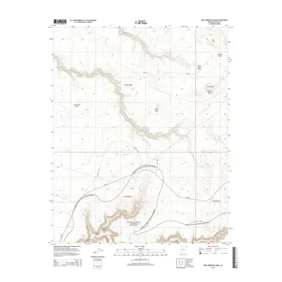
2014 Map of Red Cornfield Mesa
USGS Topo · Published 2014About this map
Canyon De Chelly National Monument dominates the southern reaches of this landscape, where the deeply carved sandstone of Canyon del Muerto reveals a complex network of drainage and elevation. High plateaus and distinctive rock formations define the northern terrain, including the namesake Red Cornfield Mesa and the uniquely labeled The Legs near the northern boundary. The area's hydrology is primarily shaped by the winding courses of Agua Sal Cr and Sheep Dip Cr, which cut through several smaller canyons such as Middle Trail Canyon and Pine Tree Canyon. Bureau of Indian Affairs routes, including Bia-n64 and Bia-8076, provide the primary access through this high-desert environment, connecting the remote mesas of Many Coyote Mesa and Gray Cactus Mesa with the larger canyon systems to the south.
Find a feature on this map
22 named features on this map. Tap any name to fly to it.
Don’t see what you’re looking for? This feature index may not catch every label — zoom into the map to look around manually.
Map Details
Editions of this 2014 Red Cornfield Mesa Map
This is the sole edition of this map. No revisions or reprints were ever made.
Other maps of this area

1892 · Canyon De Chelly
USGS Topo · 1:250,000

1954 · Shiprock
USGS Topo · 1:250,000
1955 · Sonsala Butte 1 NW
USGS Topo · 1:24,000

1955 · Sonsala Butte 2 SW
USGS Topo · 1:24,000

1955 · Sonsala Butte 4 NW
USGS Topo · 1:24,000

1955 · Sonsala Butte 2 NW
USGS Topo · 1:24,000

1955 · Sonsala Butte 2 SE
USGS Topo · 1:24,000
1955 · Sonsala Butte 3 NE
USGS Topo · 1:24,000
1955 · Sonsala Butte 2 NE
USGS Topo · 1:24,000

1955 · Sonsala Butte 1 SW
USGS Topo · 1:24,000