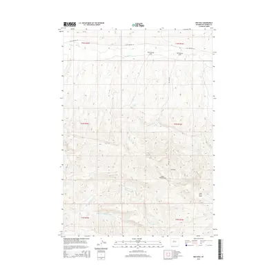
2015 Map of Red Hole
USGS Topo · Published 2015About this map
Wild Horse Butte and the surrounding drainage network of Hot Springs County define this high-altitude landscape. This 2015 survey details the arid geography where ephemeral water sources like Rock Springs and Red Springs provide critical markers across the terrain. The topography is shaped by significant erosional features such as Rock Springs Draw and Red Springs Draw, which feed into the larger Kirby Cr system. To the south, the Middle Fork Warm Springs Cr and Warm Springs Cr intersect the lower sections of the map, illustrating the complex watershed of the region. Transportation is limited to remote corridors like Black Mountain Rd and Red Hole Rd, reflecting the sparse settlement patterns and the dominance of the open range. The eponymous Red Hole and nearby Black Willow Draw further highlight the specific local landmarks of this Wyoming interior.
Find a feature on this map
18 named features on this map. Tap any name to fly to it.
Don’t see what you’re looking for? This feature index may not catch every label — zoom into the map to look around manually.
Map Details
Editions of this 2015 Red Hole Map
This is the sole edition of this map. No revisions or reprints were ever made.
Other maps of this area

1945 · Kirby
USGS Topo · 1:62,500

1946 · Kirby
USGS Topo · 1:62,500

1955 · Thermopolis
USGS Topo · 1:250,000

1955 · Arminto
USGS Topo · 1:250,000

1958 · Thermopolis
USGS Topo · 1:250,000

1958 · Arminto
USGS Topo · 1:250,000

1960 · Devil Slide
USGS Topo · 1:24,000

1960 · Coyote Hill
USGS Topo · 1:24,000
1960 · Blue Hill
USGS Topo · 1:24,000

1960 · Red Hole
USGS Topo · 1:24,000