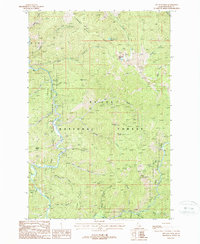
1988 Map of Red Ives Peak
USGS Topo · Published 1988About this map
The ST JOE RIVER (Wild and Scenic River) carves through the heart of this Idaho landscape, where the St Joe National Forest protects a complex network of high ridges and alpine drainages. Established forest management and recreation are centered at the Red Ives Ranger Station, which serves as a remote hub for the surrounding backcountry. Elevated landmarks such as Red Ives Peak, Simmons Peak, and Needle Peak define the horizon, while smaller water bodies like Swimming Bear Lake provide distinct geographic anchors in the higher elevations.
Find a feature on this map
35 named features on this map. Tap any name to fly to it.
Don’t see what you’re looking for? This feature index may not catch every label — zoom into the map to look around manually.
Map Details
Editions of this 1988 Red Ives Peak Map
This is the sole edition of this map. No revisions or reprints were ever made.
Other maps of this area

1911 · Lolo
USGS Topo · 1:250,000

1913 · Lolo
USGS Topo · 1:250,000

1918 · St Regis
USGS Topo · 1:125,000

1919 · St. Regis
USGS Topo · 1:125,000

1956 · Wallace
USGS Topo · 1:250,000

1956 · Hamilton
USGS Topo · 1:250,000

1957 · Illinois Peak
USGS Topo · 1:62,500

1957 · Simmons Peak
USGS Topo · 1:62,500

1959 · Hamilton
USGS Topo · 1:250,000

1960 · Wallace
USGS Topo · 1:250,000