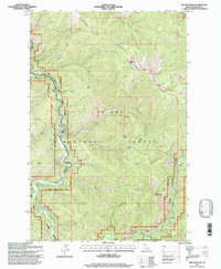
1995 Map of Red Ives Peak
USGS Topo · Published 1997About this map
The St Joe Wild and Scenic River carves a deep, winding path through the heart of the St Joe National Forest, serving as the primary geographical axis for this mid-1990s survey. The small settlement at Red Ives occupies a rare flat along the riverbanks, acting as a focal point for the surrounding mountainous terrain. High-altitude landmarks such as Red Ives Peak, Simmons Peak, and Needle Peak define the horizon, while prominent features like Simmons Ridge and Elbow Ridge separate the numerous drainages that feed the St Joe. The landscape is defined by its complex network of water sources, from the high Swimming Bear Lake to the lower reaches of Midget Creek and Color Creek. This map illustrates the intersection of Forest Service infrastructure and primitive natural features like Red Ives Spring, documenting the area before modern changes to forest management and access.
Find a feature on this map
33 named features on this map. Tap any name to fly to it.
Don’t see what you’re looking for? This feature index may not catch every label — zoom into the map to look around manually.
Map Details
Editions of this 1995 Red Ives Peak Map
This is the sole edition of this map. No revisions or reprints were ever made.
Other maps of this area

1911 · Lolo
USGS Topo · 1:250,000

1913 · Lolo
USGS Topo · 1:250,000

1918 · St Regis
USGS Topo · 1:125,000

1919 · St. Regis
USGS Topo · 1:125,000

1956 · Wallace
USGS Topo · 1:250,000

1956 · Hamilton
USGS Topo · 1:250,000

1957 · Illinois Peak
USGS Topo · 1:62,500

1957 · Simmons Peak
USGS Topo · 1:62,500

1959 · Hamilton
USGS Topo · 1:250,000

1960 · Wallace
USGS Topo · 1:250,000