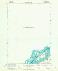
1963 Map of Red Mills
USGS Topo · Published 1965About this map
St Lawrence River defines the international boundary in this mid-century hydrographic and topographic study, where the waters of Ontario New York meet the northern reaches of St. Lawrence County. The landscape is dominated by the sprawling Galop Island, which sits as a major geographic feature between the American and Canadian shores. Navigational markers including a Tower, several Light placements, and a Weir underscore the importance of the river's channel during this era of Seaway operations. On the mainland, the small settlement of Red Mills is situated near the riverbanks, served by the local Ross Road. This 1963 field check offers a precise view of the river's islands, including Benedict Island, during a period of significant maritime coordination between the Canada United States border.
Find a feature on this map
12 named features on this map. Tap any name to fly to it.
Don’t see what you’re looking for? This feature index may not catch every label — zoom into the map to look around manually.
Map Details
Editions of this 1963 Red Mills Map
This is the sole edition of this map. No revisions or reprints were ever made.
Other maps of this area

1904 · Lisbon
USGS Topo · 1:48,000

1904 · Ogdensburg
USGS Topo · 1:62,500

1905 · Ogdensburg
USGS Topo · 1:62,500

1906 · Brier Hill
USGS Topo · 1:62,500

1906 · Red Mills
USGS Topo · 1:62,500

1943 · Ogdensburg East
USGS Topo · 1:31,680

1943 · Lisbon
USGS Topo · 1:31,680
1943 · Red Mills
USGS Topo · 1:31,680
1943 · Sparrowhawk Point
USGS Topo · 1:31,680
1943 · Ogdensburg West
USGS Topo · 1:31,680