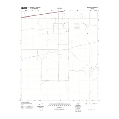
2010 Map of Red Mountain
USGS Topo · Published 2010About this map
Red Mountain and the Snake Hills rise above the high desert floor in this 2010 survey of Luna County. The landscape is defined by a sparse but organized grid of county roads and industrial infrastructure, including a prominent network of the Pipeline Rd. Transportation through this corner of New Mexico is anchored by the I 10 Frontage Rd in the north, which parallels the interstate corridor. Occasional residential or ranch structures are scattered along Pelayo Rd SW and Pearl Union Rd SW, illustrating the modern rural development of the region. Drainage is carved into the terrain by Jones Spring Draw in the northeast, providing a natural contrast to the geometric lines of Canto Rd and Chives Rd Sw.
Find a feature on this map
19 named features on this map. Tap any name to fly to it.
Don’t see what you’re looking for? This feature index may not catch every label — zoom into the map to look around manually.
Map Details
Editions of this 2010 Red Mountain Map
This is the sole edition of this map. No revisions or reprints were ever made.
Other maps of this area

1899 · Deming
USGS Topo · 1:125,000

1915 · Deming
USGS Topo · 1:125,000

1954 · Silver City
USGS Topo · 1:250,000

1955 · Las Cruces
USGS Topo · 1:250,000

1958 · Las Cruces
USGS Topo · 1:250,000

1958 · Silver City
USGS Topo · 1:250,000

1962 · Silver City
USGS Topo · 1:250,000

1963 · Gage
USGS Topo · 1:24,000
1963 · Gage SE
USGS Topo · 1:24,000
1964 · Grandmother Mountain East
USGS Topo · 1:24,000