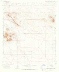
1964 Map of Grandmother Mountain East
USGS Topo · Published 1966About this map
Little Grandmother Mountain and the larger Grandmother Mountain massif dominate this arid New Mexico landscape, which was mapped in the mid-1960s. The terrain is defined by the ephemeral Cow Springs Draw and a network of ranching infrastructure essential for cattle in high-desert conditions. Several named water sources and family landmarks such as Stearns Windmill, Dunn Windmill, and Benedict Ranch provide specific points of interest for genealogists tracing regional land use.
Find a feature on this map
15 named features on this map. Tap any name to fly to it.
Don’t see what you’re looking for? This feature index may not catch every label — zoom into the map to look around manually.
Map Details
Editions of this 1964 Grandmother Mountain East Map
2 editions found
Other maps of this area

1899 · Deming
USGS Topo · 1:125,000

1915 · Deming
USGS Topo · 1:125,000

1954 · Silver City
USGS Topo · 1:250,000

1955 · Las Cruces
USGS Topo · 1:250,000

1958 · Las Cruces
USGS Topo · 1:250,000

1958 · Silver City
USGS Topo · 1:250,000

1962 · Silver City
USGS Topo · 1:250,000
1963 · Antelope Hill
USGS Topo · 1:24,000
1963 · Cow Springs Mountain
USGS Topo · 1:24,000

1963 · Gage NW
USGS Topo · 1:24,000