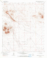
1964 Map of Grandmother Mountain East
USGS Topo · Published 1990About this map
Grandmother Mountain and Little Grandmother Mountain dominate the arid New Mexico landscape in this mid-century survey of eastern Luna County. This area represents a classic desert ranching environment, where survival and movement are dictated by water sources and natural topography. The drainage of Cow Springs Draw provides a central axis for the map, around which several ranching improvements are clustered. Family-named sites like Davis Ranch and Benedict Ranch highlight the importance of private landholdings, while a series of remote water stations including Stevens Windmill, New Windmill, and Gage Windmill demonstrate the infrastructure required for livestock management in the high desert. Modern industrial progress is visible in the form of a long Pipeline and a Radio Tower, contrasting with traditional features like the Clabber Top Hill and a localized Gravel Pit.
Find a feature on this map
15 named features on this map. Tap any name to fly to it.
Don’t see what you’re looking for? This feature index may not catch every label — zoom into the map to look around manually.
Map Details
Editions of this 1964 Grandmother Mountain East Map
2 editions found
Other maps of this area

1899 · Deming
USGS Topo · 1:125,000

1915 · Deming
USGS Topo · 1:125,000

1954 · Silver City
USGS Topo · 1:250,000

1955 · Las Cruces
USGS Topo · 1:250,000

1958 · Las Cruces
USGS Topo · 1:250,000

1958 · Silver City
USGS Topo · 1:250,000

1962 · Silver City
USGS Topo · 1:250,000
1963 · Antelope Hill
USGS Topo · 1:24,000
1963 · Cow Springs Mountain
USGS Topo · 1:24,000

1963 · Gage NW
USGS Topo · 1:24,000