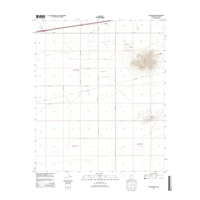
2013 Map of Red Mountain
USGS Topo · Published 2013About this map
Tunis sits along the northern edge of this high desert landscape, positioned where the infrastructure of NM-418 meets the regional grid in western New Mexico. The terrain is defined by dramatic isolated peaks, most notably the towering Red Mtn and the smaller Snake Hills to its south, which rise sharply above the surrounding flats. These formations are drained by ephemeral features like Jones Spring Draw, which cuts through the northeastern corner of the map near Pancho Rd SW.
Find a feature on this map
25 named features on this map. Tap any name to fly to it.
Don’t see what you’re looking for? This feature index may not catch every label — zoom into the map to look around manually.
Map Details
Editions of this 2013 Red Mountain Map
This is the sole edition of this map. No revisions or reprints were ever made.
Other maps of this area

1899 · Deming
USGS Topo · 1:125,000

1915 · Deming
USGS Topo · 1:125,000

1954 · Silver City
USGS Topo · 1:250,000

1955 · Las Cruces
USGS Topo · 1:250,000

1958 · Las Cruces
USGS Topo · 1:250,000

1958 · Silver City
USGS Topo · 1:250,000

1962 · Silver City
USGS Topo · 1:250,000

1963 · Gage
USGS Topo · 1:24,000
1963 · Gage SE
USGS Topo · 1:24,000
1964 · Grandmother Mountain East
USGS Topo · 1:24,000