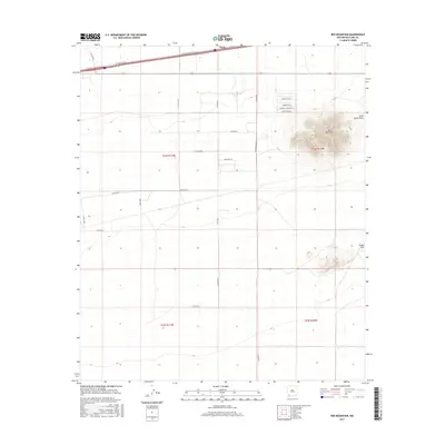
2017 Map of Red Mountain
USGS Topo · Published 2017About this map
Tunis sits along the northern corridor of this 2017 study of the high desert of Luna County. The landscape is dominated by the volcanic profile of Red Mountain, which rises sharply above the surrounding basin, and the Snake Hills to the southeast. Water movement in this arid environment is traced by the seasonal Jones Spring Draw, which cuts through the northeastern reaches of the quadrangle. The map details a transition from the structured transportation corridor of the I-10 Frontage Rd to a network of local routes with culturally evocative names like Pancho Rd Sw, Sombrero Rd, and Pearlonion Rd. These roads suggest a pattern of rural land division and ranching access that characterizes the modern Chihuahuan Desert landscape near the Mexican border.
Find a feature on this map
25 named features on this map. Tap any name to fly to it.
Don’t see what you’re looking for? This feature index may not catch every label — zoom into the map to look around manually.
Map Details
Editions of this 2017 Red Mountain Map
This is the sole edition of this map. No revisions or reprints were ever made.
Other maps of this area

1899 · Deming
USGS Topo · 1:125,000

1915 · Deming
USGS Topo · 1:125,000

1954 · Silver City
USGS Topo · 1:250,000

1955 · Las Cruces
USGS Topo · 1:250,000

1958 · Las Cruces
USGS Topo · 1:250,000

1958 · Silver City
USGS Topo · 1:250,000

1962 · Silver City
USGS Topo · 1:250,000

1963 · Gage
USGS Topo · 1:24,000
1963 · Gage SE
USGS Topo · 1:24,000
1964 · Grandmother Mountain East
USGS Topo · 1:24,000