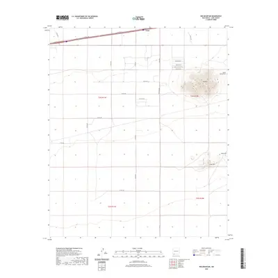
2020 Map of Red Mountain
USGS Topo · Published 2020About this map
The settlement of Tunis sits at the northern edge of this high-desert landscape in Luna County, situated along the corridor of the I-10 Frontage Rd. Dominating the eastern portion of the sheet is the volcanic profile of Red Mtn, which rises above a series of family-named local roads including Pancho Rd SW and Pueblo De Oro Rd SW. The terrain transitions into the distinct topography of the Snake Hills in the southeast, while the ephemeral Jones Spring Draw provides a glimpse into the regional drainage patterns of this arid basin. This modern 2020 survey illustrates the sparse rural development and significant road network characteristic of the New Mexico borderlands, where wide open spaces are punctuated by isolated peaks and seasonal watercourses like Chives Rd and Pearlonion Rd.
Find a feature on this map
25 named features on this map. Tap any name to fly to it.
Don’t see what you’re looking for? This feature index may not catch every label — zoom into the map to look around manually.
Map Details
Editions of this 2020 Red Mountain Map
This is the sole edition of this map. No revisions or reprints were ever made.
Other maps of this area

1899 · Deming
USGS Topo · 1:125,000

1915 · Deming
USGS Topo · 1:125,000

1954 · Silver City
USGS Topo · 1:250,000

1955 · Las Cruces
USGS Topo · 1:250,000

1958 · Las Cruces
USGS Topo · 1:250,000

1958 · Silver City
USGS Topo · 1:250,000

1962 · Silver City
USGS Topo · 1:250,000

1963 · Gage
USGS Topo · 1:24,000
1963 · Gage SE
USGS Topo · 1:24,000
1964 · Grandmother Mountain East
USGS Topo · 1:24,000