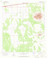
1965 Map of Red Mountain
USGS Topo · Published 1967About this map
Red Mountain and the southern slopes of the Snake Hills anchor this high desert landscape in Luna County. The arid terrain is defined by its transit and utility infrastructure, with a prominent pipeline and several transmission lines crossing the scrubland. Along the northern edge, the Southern Pacific railroad corridor runs parallel to a major highway, passing through the small siding of Tunis.
Find a feature on this map
6 named features on this map. Tap any name to fly to it.
Don’t see what you’re looking for? This feature index may not catch every label — zoom into the map to look around manually.
Map Details
Editions of this 1965 Red Mountain Map
This is the sole edition of this map. No revisions or reprints were ever made.
Other maps of this area

1899 · Deming
USGS Topo · 1:125,000

1915 · Deming
USGS Topo · 1:125,000

1954 · Silver City
USGS Topo · 1:250,000

1955 · Las Cruces
USGS Topo · 1:250,000

1958 · Las Cruces
USGS Topo · 1:250,000

1958 · Silver City
USGS Topo · 1:250,000

1962 · Silver City
USGS Topo · 1:250,000

1963 · Gage
USGS Topo · 1:24,000
1963 · Gage SE
USGS Topo · 1:24,000
1964 · Grandmother Mountain East
USGS Topo · 1:24,000