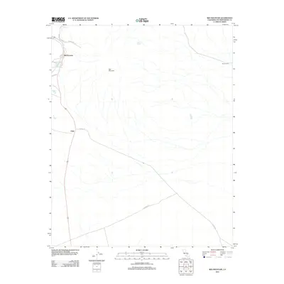
2012 Map of Red Mountain
USGS Topo · Published 2012About this map
Atolia and the nearby community of Red Mountain anchor the western edge of this 2012 survey in San Bernardino County. Located in a high desert environment, the landscape is defined by the eponymous Red Mountain peak and a sparse network of through-roads. Settlement patterns here are tied to the historical mining corridors along Trona Rd, where small clusters of development stand against the expansive terrain. Farther east, the map reveals isolated outposts like Browns Ranch and the solitary water source of Squaw Spring. Long, straight desert routes such as Hoffman Rd and Cuddeback Rd connect these remote points, illustrating the vast distances between desert habitations. The map provides a clear view of the modern infrastructure and rural roads that sustain these small Mojave Desert communities.
Find a feature on this map
12 named features on this map. Tap any name to fly to it.
Don’t see what you’re looking for? This feature index may not catch every label — zoom into the map to look around manually.
Map Details
Editions of this 2012 Red Mountain Map
This is the sole edition of this map. No revisions or reprints were ever made.
Other maps of this area

1903 · Randsburg
USGS Topo · 1:62,500

1911 · Randsburg
USGS Topo · 1:62,500

1912 · Randsburg
USGS Topo · 1:62,500

1915 · Searles Lake
USGS Topo · 1:250,000

1947 · Trona
USGS Topo · 1:250,000

1948 · Trona
USGS Topo · 1:250,000

1953 · Trona
USGS Topo · 1:250,000
1954 · Boron
USGS Topo · 1:62,500

1954 · Cuddeback Lake
USGS Topo · 1:62,500

1956 · Fremont Peak
USGS Topo · 1:62,500