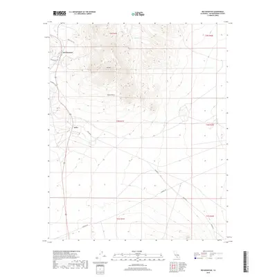
2018 Map of Red Mountain
USGS Topo · Published 2018About this map
Red Mountain and the high desert landscape of San Bernardino County are defined by a network of mining-era roads and rugged peaks in this modern survey. The settlement of Atolia sits in the shadows of Red Mtn, an area historically tied to the tungsten and gold mining booms of the early 20th century. This 2018 data illustrates how the ancient travel routes of the Mojave Desert remain etched into the topography, with Randsburg Cutoff and Hoffman Rd navigating the varied elevations. To the north, Squaw Spring provides a rare water reference point in an otherwise arid stretch of public lands and townships. The map serves as a contemporary record of how human habitation and industrial infrastructure persist within the high-elevation terrain of the northwestern Mojave.
Find a feature on this map
16 named features on this map. Tap any name to fly to it.
Don’t see what you’re looking for? This feature index may not catch every label — zoom into the map to look around manually.
Map Details
Editions of this 2018 Red Mountain Map
This is the sole edition of this map. No revisions or reprints were ever made.
Other maps of this area

1903 · Randsburg
USGS Topo · 1:62,500

1911 · Randsburg
USGS Topo · 1:62,500

1912 · Randsburg
USGS Topo · 1:62,500

1915 · Searles Lake
USGS Topo · 1:250,000

1947 · Trona
USGS Topo · 1:250,000

1948 · Trona
USGS Topo · 1:250,000

1953 · Trona
USGS Topo · 1:250,000
1954 · Boron
USGS Topo · 1:62,500

1954 · Cuddeback Lake
USGS Topo · 1:62,500

1956 · Fremont Peak
USGS Topo · 1:62,500