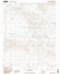
1996 Map of Red Pass Lake NW
USGS Topo · Published 1998About this map
Fort Irwin Military Reservation dominates the landscape of this high desert region in San Bernardino County, where topographical detail reveals a strictly managed landscape. The terrain is defined by the sharp elevations of the Ava Watz Mountains, featuring peaks such as Grave Summit. Scattered evidence of early exploration and utility is visible through isolated labels for Prospects and a Radio Facility, alongside a specific marker for a Grave. The inclusion of No Name Lake underscores the arid environment and the functional, often utilitarian naming conventions used in this military-managed territory during the mid-1990s. This survey, based on photography from the 1980s and updated through 1996, provides a window into the infrastructure and natural landforms preserved within the reservation boundaries before the turn of the century.
Find a feature on this map
9 named features on this map. Tap any name to fly to it.
Don’t see what you’re looking for? This feature index may not catch every label — zoom into the map to look around manually.
Map Details
Editions of this 1996 Red Pass Lake NW Map
This is the sole edition of this map. No revisions or reprints were ever made.
Other maps of this area

1933 · Avawatz Mountains
USGS Topo · 1:250,000

1947 · Trona
USGS Topo · 1:250,000

1948 · Red Pass Lake
USGS Topo · 1:62,500

1948 · Trona
USGS Topo · 1:250,000

1948 · Leach Lake
USGS Topo · 1:62,500

1948 · Avawatz Pass
USGS Topo · 1:62,500

1948 · Tiefort Mountains
USGS Topo · 1:62,500

1951 · Tiefort Mountains
USGS Topo · 1:62,500

1951 · Avawatz Pass
USGS Topo · 1:62,500

1951 · Red Pass Lake
USGS Topo · 1:62,500