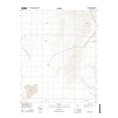
2015 Map of Red Pass Lake
USGS Topo · Published 2015About this map
Red Pass Lake defines the southwestern corner of this arid landscape, a prominent dry lake bed characteristic of the high Mojave Desert in San Bernardino County. The topography is shaped by complex drainage patterns and rising elevations as the land moves toward the eastern and northern portions of the quadrangle. This 2015 survey by the U.S. Geological Survey provides an intricate view of the desert floor, where alluvial fans and washes dictate the natural transit routes through the basin. Large-scale land divisions, including t14n r6e and t15n r7e, are clearly delineated, mapping out the systematic survey of this sparsely populated region. For those studying the environmental history or the Public Land Survey System in California, the map offers a precise record of the physical geography and administrative boundaries in this remote section of the Mojave.
Find a feature on this map
8 named features on this map. Tap any name to fly to it.
Don’t see what you’re looking for? This feature index may not catch every label — zoom into the map to look around manually.
Map Details
Editions of this 2015 Red Pass Lake Map
This is the sole edition of this map. No revisions or reprints were ever made.
Other maps of this area

1933 · Avawatz Mountains
USGS Topo · 1:250,000

1947 · Trona
USGS Topo · 1:250,000

1948 · Red Pass Lake
USGS Topo · 1:62,500

1948 · Trona
USGS Topo · 1:250,000

1948 · Cave Mountain
USGS Topo · 1:62,500

1951 · Cave Mountain
USGS Topo · 1:62,500

1951 · Red Pass Lake
USGS Topo · 1:62,500

1953 · Trona
USGS Topo · 1:250,000
1956 · Soda Lake
USGS Topo · 1:62,500

1956 · Baker
USGS Topo · 1:62,500