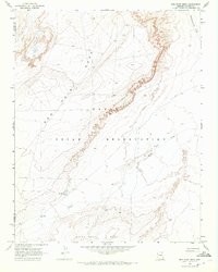
1968 Map of Red Point Mesa
USGS Topo · Published 1972About this map
Navajo Indian Reservation lands dominate this late 1960s topographic study, characterized by the dramatic escarpments of Red Point Mesa and White Rock Mesa. The arid landscape is defined by its water sources, most notably the winding course of Tyende Creek and the smaller Agende Creek. Near the base of the red mesas, Tah neh choa ah Spring serves as a critical natural landmark alongside several wells. The presence of a Corral and scattered Drill Holes indicates a territory utilized for both livestock and mineral exploration. The boundary between Navajo Co and Apache Co runs through the western portion of the quadrangle, cutting across high desert features like Greasewood Flat. This survey provides a precise look at the land's natural contours and early improvements before further modern development reached this part of Northern Arizona.
Find a feature on this map
11 named features on this map. Tap any name to fly to it.
Don’t see what you’re looking for? This feature index may not catch every label — zoom into the map to look around manually.
Map Details
Editions of this 1968 Red Point Mesa Map
This is the sole edition of this map. No revisions or reprints were ever made.
Other maps of this area

1883 · Marsh Pass
USGS Topo · 1:250,000

1892 · Marsh Pass
USGS Topo · 1:250,000

1892 · Canyon De Chelly
USGS Topo · 1:250,000

1952 · Dinnehotso
USGS Topo · 1:62,500

1952 · Agathla Peak 1 SE
USGS Topo · 1:24,000

1952 · Setsiltso Springs 2 SW
USGS Topo · 1:24,000

1952 · Setsiltso Springs 2 SE
USGS Topo · 1:24,000

1952 · Agathla Peak
USGS Topo · 1:62,500

1954 · Shiprock
USGS Topo · 1:250,000

1956 · Marble Canyon
USGS Topo · 1:250,000