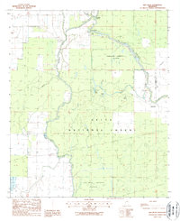
1988 Map of Red Rock
USGS Topo · Published 1988About this map
The Delta National Forest dominates this landscape in Sharkey County, defining a complex ecosystem of seasonal wetlands and managed water resources during the late 1980s. The Big Sunflower River and Little Sunflower River wind through the territory, feeding an intricate network of waterways like Howlett Bayou and Coon Bayou. The presence of the Sunflower Greentree Reservoir and Long Bayou Greentree Reservoir illustrates the sophisticated water management systems used to maintain bottomland hardwood habitats.
Find a feature on this map
27 named features on this map. Tap any name to fly to it.
Don’t see what you’re looking for? This feature index may not catch every label — zoom into the map to look around manually.
Map Details
Editions of this 1988 Red Rock Map
This is the sole edition of this map. No revisions or reprints were ever made.
Other maps of this area

1939 · Onward
USGS Topo · 1:62,500

1939 · Lorenzen
USGS Topo · 1:62,500

1940 · Mechanicsburg
USGS Topo · 1:62,500

1955 · Jackson
USGS Topo · 1:250,000

1961 · Jackson
USGS Topo · 1:250,000

1961 · Bayland
USGS Topo · 1:62,500

1962 · Jackson
USGS Topo · 1:250,000

1963 · Mechanicsburg
USGS Topo · 1:62,500

1963 · Onward
USGS Topo · 1:62,500

1964 · Lorenzen
USGS Topo · 1:62,500