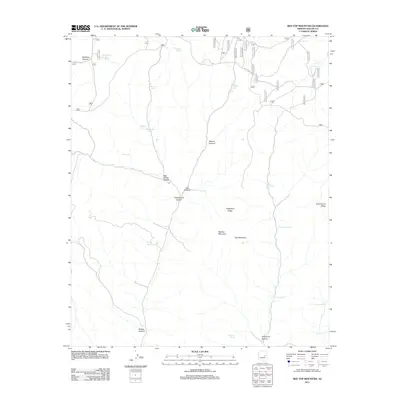
2011 Map of Red Top Mountain
USGS Topo · Published 2011About this map
Red Top Mountain and Hop Mountain anchor this landscape along the high country of Navajo County, where the topography is defined by the significant ascent toward the Mogollon Rim Rd. The 2011 survey reveals an intricate network of drainage systems and canyons, including McCleve Canyon, Walnut Canyon, and Yellowstone Canyon, which cut through the high ridges. This era of land management is heavily oriented around water conservation and livestock, evidenced by the numerous catchment tanks such as Yellowjacket Tank, Walnut Tank, and Charco Tank. These man-made features, alongside natural water sources like Turkey Spring and Cottonwood Spring, illustrate the essential infrastructure required to sustain life and industry in the arid Arizona high desert. The presence of Telephone Ridge and Telephone Canyon suggests historical utility corridors that have long traversed these peaks.
Find a feature on this map
36 named features on this map. Tap any name to fly to it.
Don’t see what you’re looking for? This feature index may not catch every label — zoom into the map to look around manually.
Map Details
Editions of this 2011 Red Top Mountain Map
This is the sole edition of this map. No revisions or reprints were ever made.
Other maps of this area

1886 · Holbrook
USGS Topo · 1:250,000

1893 · Holbrook
USGS Topo · 1:250,000

1954 · Holbrook
USGS Topo · 1:250,000

1957 · Holbrook
USGS Topo · 1:250,000

1958 · Holbrook
USGS Topo · 1:250,000

1960 · Holbrook
USGS Topo · 1:250,000

1961 · Clay Springs
USGS Topo · 1:62,500
1961 · Show Low
USGS Topo · 1:62,500

1961 · Cibecue
USGS Topo · 1:62,500
1970 · Show Low North
USGS Topo · 1:24,000