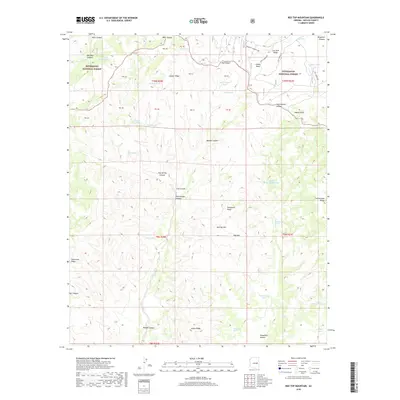
2018 Map of Red Top Mountain
USGS Topo · Published 2018About this map
Sitgreaves National Forest covers this portion of the Mogollon Plateau, a landscape defined by its network of deep canyons and volcanic ridges. Water sources are critical identifiers in this arid environment, marked by a series of springs and tanks including Box Spring, Yellowstone Tank, and Telephone Spring. The topography is dominated by prominent elevations such as Red Top Mtn and Hop Mtn, while the Lookout Connector indicates the presence of forest management and fire observation infrastructure. Numerous canyons like Walnut Canyon and Cub Canyon carve through the plateau, creating a complex terrain that has historically influenced travel and land use in Navajo County. The arrangement of stock tanks like Yellowjacket Tank and Middle Cottonwood Tank suggests a landscape utilized for seasonal grazing and resource management within the national forest boundaries.
Find a feature on this map
59 named features on this map. Tap any name to fly to it.
Don’t see what you’re looking for? This feature index may not catch every label — zoom into the map to look around manually.
Map Details
Editions of this 2018 Red Top Mountain Map
This is the sole edition of this map. No revisions or reprints were ever made.
Other maps of this area

1886 · Holbrook
USGS Topo · 1:250,000

1893 · Holbrook
USGS Topo · 1:250,000

1954 · Holbrook
USGS Topo · 1:250,000

1957 · Holbrook
USGS Topo · 1:250,000

1958 · Holbrook
USGS Topo · 1:250,000

1960 · Holbrook
USGS Topo · 1:250,000

1961 · Clay Springs
USGS Topo · 1:62,500
1961 · Show Low
USGS Topo · 1:62,500

1961 · Cibecue
USGS Topo · 1:62,500
1970 · Show Low North
USGS Topo · 1:24,000