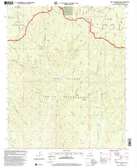
1998 Map of Red Top Mountain
USGS Topo · Published 2000About this map
The Mogollon Rim escarpment dominates the northern reaches of this landscape, marking the transition between the high plateau and the broken canyons of the Fort Apache Indian Reservation. This 1998 revision by the USDA Forest Service highlights a terrain defined by its water sources, where numerous cattle tanks and springs like Yellow Jacket Tank and Telephone Spring supported livestock grazing in the Sitgreaves National Forest.
Find a feature on this map
53 named features on this map. Tap any name to fly to it.
Don’t see what you’re looking for? This feature index may not catch every label — zoom into the map to look around manually.
Map Details
Editions of this 1998 Red Top Mountain Map
This is the sole edition of this map. No revisions or reprints were ever made.
Other maps of this area

1886 · Holbrook
USGS Topo · 1:250,000

1893 · Holbrook
USGS Topo · 1:250,000

1954 · Holbrook
USGS Topo · 1:250,000

1957 · Holbrook
USGS Topo · 1:250,000

1958 · Holbrook
USGS Topo · 1:250,000

1960 · Holbrook
USGS Topo · 1:250,000

1961 · Clay Springs
USGS Topo · 1:62,500
1961 · Show Low
USGS Topo · 1:62,500

1961 · Cibecue
USGS Topo · 1:62,500
1970 · Show Low North
USGS Topo · 1:24,000