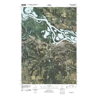
2010 Map of Red Wing
USGS Topo · Published 2010About this map
The Mississippi River defines the landscape of this border region between Minnesota and Wisconsin, carving a wide valley filled with intricate waterways like Trenton Slough and Vermillion Slough. The city of Red Wing serves as the primary hub, anchored by the Red Wing Post Office and the Riverfront Centre. Prominent geological landmarks such as Barn Bluff and Sorins Bluff rise above the river plains, while the Dwight D Eisenhower Bridge provides a vital link across the water toward Hager City.
Find a feature on this map
72 named features on this map. Tap any name to fly to it.
Don’t see what you’re looking for? This feature index may not catch every label — zoom into the map to look around manually.
Map Details
Editions of this 2010 Red Wing Map
This is the sole edition of this map. No revisions or reprints were ever made.
Other maps of this area

1940 · Maiden Rock
USGS Topo · 1:62,500

1944 · Red Wing
USGS Topo · 1:62,500

1950 · Maiden Rock
USGS Topo · 1:62,500

1951 · Lake City
USGS Topo · 1:62,500

1952 · Red Wing
USGS Topo · 1:62,500

1953 · Saint Paul
USGS Topo · 1:250,000

1959 · Saint Paul
USGS Topo · 1:250,000

1968 · Goodhue East
USGS Topo · 1:24,000
1968 · Goodhue West
USGS Topo · 1:24,000
1974 · Lake City NW
USGS Topo · 1:24,000