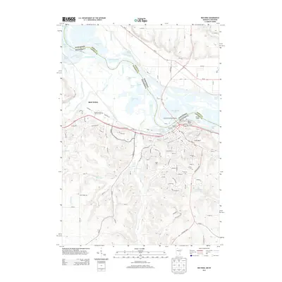
2013 Map of Red Wing
USGS Topo · Published 2013About this map
Red Wing occupies a dramatic position on the Mississippi River, framed by the prominent heights of Barn Bluff and Sorins Bluff. This 2013 landscape shows the dense street grid of the city center transitioning into the valleys of Hay Creek and Trout Brook. The riverfront is a hub of connectivity, featuring the Dwight D Eisenhower Bridge and the Riverfront Centre, while the complex hydrology of the river valley is evident in the numerous backwaters such as Sturgeon Lake, Vermillion Slough, and Gantenbein Lake. Several local heritage sites are documented throughout the city and its periphery, including Oakwood Cem, Calvary Cem, and the Goodhue County Poor Farm Cem. The map illustrates how development has navigated the steep terrain of Coon Hill and the winding course of the Trimbelle River as it enters the Mississippi from the Wisconsin side.
Find a feature on this map
125 named features on this map. Tap any name to fly to it.
Don’t see what you’re looking for? This feature index may not catch every label — zoom into the map to look around manually.
Map Details
Editions of this 2013 Red Wing Map
This is the sole edition of this map. No revisions or reprints were ever made.
Other maps of this area

1940 · Maiden Rock
USGS Topo · 1:62,500

1944 · Red Wing
USGS Topo · 1:62,500

1950 · Maiden Rock
USGS Topo · 1:62,500

1951 · Lake City
USGS Topo · 1:62,500

1952 · Red Wing
USGS Topo · 1:62,500

1953 · Saint Paul
USGS Topo · 1:250,000

1959 · Saint Paul
USGS Topo · 1:250,000

1968 · Goodhue East
USGS Topo · 1:24,000
1968 · Goodhue West
USGS Topo · 1:24,000
1974 · Lake City NW
USGS Topo · 1:24,000