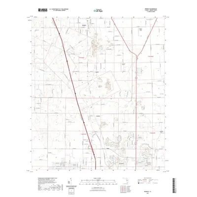
2021 Map of Reddick
USGS Topo · Published 2021About this map
Reddick serves as the northern anchor of this north-central Florida corridor, situated along a series of small settlements that follow the north-south transport lines. The landscape is characterized by a mix of agricultural tracts and aviation-focused properties, as evidenced by several private airfields including Wings-N-Wheels Airport and Lee Farms Airport. Between the primary settlements of Lowell, Martin, and Zuber, the map documents the proximity of small-town centers and rural cemeteries, such as the Baptist Cem in the northwest and Union Cem further south. The pattern of development follows historic county roads and modern thoroughfares like NW Gainesville Rd, which connect these established communities to the southern terminus at Kendrick. This record reflects the area's continued reliance on a mix of local road networks and specialized infrastructure like the Jumbolair Airport near the eastern boundary.
Find a feature on this map
128 named features on this map. Tap any name to fly to it.
Don’t see what you’re looking for? This feature index may not catch every label — zoom into the map to look around manually.
Map Details
Editions of this 2021 Reddick Map
This is the sole edition of this map. No revisions or reprints were ever made.
Other maps of this area

1892 · Dunnellon
USGS Topo · 1:62,500

1893 · Citra
USGS Topo · 1:62,500

1894 · Dunnellon
USGS Topo · 1:62,500

1895 · Williston
USGS Topo · 1:62,500

1895 · Citra
USGS Topo · 1:62,500

1895 · Ocala
USGS Topo · 1:62,500

1954 · Cotton Plant
USGS Topo · 1:24,000

1954 · Dunnellon
USGS Topo · 1:62,500

1954 · Gainesville
USGS Topo · 1:250,000

1958 · Gainesville
USGS Topo · 1:250,000