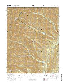
2016 Map of Reddish Knob
USGS Topo · Published 2016About this map
Shenandoah Mountain forms a natural spine through this portion of the George Washington National Forest, serving as the high-elevation border between Virginia and West Virginia. This landscape is defined by its deep ridges and narrow hollows, such as Daggy Camp Hollow, which channel various branches of the Little River and N Fork Little River. The map highlights the essential water management infrastructure of the region, including the Hone Quarry Reservoir, Briery Branch Reservoir, and Hearthstone Lake. These water bodies are tucked into the steep terrain below peaks like Reddish Knob and Sand Spring Mtn. Access is provided by narrow forest routes such as Briery Branch Rd and Tillman Rd, which follow the contours of landforms like Wolf Ridge and Hone Quarry Ridge.
Find a feature on this map
47 named features on this map. Tap any name to fly to it.
Don’t see what you’re looking for? This feature index may not catch every label — zoom into the map to look around manually.
Map Details
Editions of this 2016 Reddish Knob Map
This is the sole edition of this map. No revisions or reprints were ever made.
Other maps of this area

1892 · Franklin
USGS Topo · 1:125,000

1894 · Staunton
USGS Topo · 1:125,000

1896 · Franklin
USGS Topo · 1:125,000

1922 · Fort Seybert
USGS Topo · 1:48,000

1922 · Circleville
USGS Topo · 1:62,500

1924 · Circleville
USGS Topo · 1:48,000

1924 · Mc Dowell
USGS Topo · 1:62,500

1924 · Fort Seybert
USGS Topo · 1:62,500

1944 · Parnassus
USGS Topo · 1:62,500

1944 · Mc Dowell
USGS Topo · 1:62,500