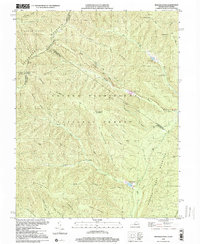
1999 Map of Reddish Knob
USGS Topo · Published 2000About this map
Reddish Knob stands as the prominent height in this mountain landscape, marking the high boundary between Augusta and Rockingham counties along the West Virginia and Virginia state line. This portion of the George Washington National Forest is defined by a dense network of high ridges, including Narrow Back Mountain, California Ridge, and Sugar Grove Mountain. The topography indicates a landscape managed for both water resources and recreation during the late twentieth century, evidenced by several water control structures such as Hone Quarry Dam, Briery Branch Dam, and Hearthstone Lake. Local industry and land use are further marked by the presence of Mines near the Little River and a system of fire and access routes like the Briery Branch Path. Surveyed overlooks such as Heiliger Kanzel Overlook and Stony Run Overlook highlight the area's established character as a vantage point for the surrounding Allegheny mountains.
Find a feature on this map
49 named features on this map. Tap any name to fly to it.
Don’t see what you’re looking for? This feature index may not catch every label — zoom into the map to look around manually.
Map Details
Editions of this 1999 Reddish Knob Map
This is the sole edition of this map. No revisions or reprints were ever made.
Other maps of this area

1892 · Franklin
USGS Topo · 1:125,000

1894 · Staunton
USGS Topo · 1:125,000

1896 · Franklin
USGS Topo · 1:125,000

1922 · Fort Seybert
USGS Topo · 1:48,000

1922 · Circleville
USGS Topo · 1:62,500

1924 · Circleville
USGS Topo · 1:48,000

1924 · Mc Dowell
USGS Topo · 1:62,500

1924 · Fort Seybert
USGS Topo · 1:62,500

1944 · Parnassus
USGS Topo · 1:62,500

1944 · Mc Dowell
USGS Topo · 1:62,500