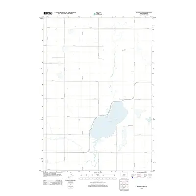
2012 Map of Redfield SW
USGS Topo · Published 2012About this map
Cottonwood Lake dominates the central landscape of this Spink County territory, serving as a primary hydrological feature alongside the winding path of Medicine Cr. The area is characterized by a precise sectional grid of township roads, with north-south avenues such as 372nd Ave and 378th Ave crossing east-west streets like 174th St and 182nd St. This structured layout reflects the enduring influence of the Public Land Survey System on South Dakota's agricultural plains. Elevated terrain is represented by the modest prominence of Bald Mountain to the north of the lake. The map details the rural infrastructure of the early 21st century, showing the placement of farmsteads and the residential corridor along Cottonwood Ln, illustrating how settlement remains tightly tied to the region's few significant water sources and topographic landmarks.
Find a feature on this map
22 named features on this map. Tap any name to fly to it.
Don’t see what you’re looking for? This feature index may not catch every label — zoom into the map to look around manually.
Map Details
Editions of this 2012 Redfield SW Map
This is the sole edition of this map. No revisions or reprints were ever made.
Other maps of this area

1899 · Redfield
USGS Topo · 1:125,000

1953 · Redfield North
USGS Topo · 1:24,000

1953 · Huron
USGS Topo · 1:250,000

1954 · Huron
USGS Topo · 1:250,000

1966 · Burdette
USGS Topo · 1:24,000

1966 · Redfield South
USGS Topo · 1:24,000
1966 · Rockham
USGS Topo · 1:24,000
1966 · Rockham SE
USGS Topo · 1:24,000
1966 · Zell
USGS Topo · 1:24,000

1966 · Redfield SW
USGS Topo · 1:24,000