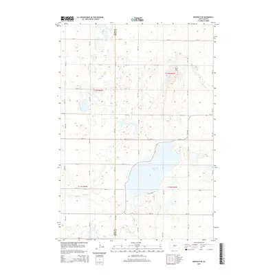
2015 Map of Redfield SW
USGS Topo · Published 2015About this map
Cottonwood Lake anchors the southeastern landscape of this 2015 survey, serving as a primary hydrologic landmark near the intersection of Cottonwood Ln and several section-line roads. The terrain is characterized by a high density of small glacial depressions and wetlands common to the Missouri Coteau region. In the northeastern portion of the sheet, the elevation rises toward the prominent height of Bald Mtn, providing a distinct contrast to the lower-lying lake basin. The map clearly delineates the north-south boundary between Hand Co and Spink Co, which follows 374th Ave. Water features such as the winding Medicine Cr in the south emphasize the drainage patterns across this agricultural prairie, where the rigid grid of rural routes like 174th St and 372nd Ave defines the property and transport network of the era.
Find a feature on this map
25 named features on this map. Tap any name to fly to it.
Don’t see what you’re looking for? This feature index may not catch every label — zoom into the map to look around manually.
Map Details
Editions of this 2015 Redfield SW Map
This is the sole edition of this map. No revisions or reprints were ever made.
Other maps of this area

1899 · Redfield
USGS Topo · 1:125,000

1953 · Redfield North
USGS Topo · 1:24,000

1953 · Huron
USGS Topo · 1:250,000

1954 · Huron
USGS Topo · 1:250,000

1966 · Burdette
USGS Topo · 1:24,000

1966 · Redfield South
USGS Topo · 1:24,000
1966 · Rockham
USGS Topo · 1:24,000
1966 · Rockham SE
USGS Topo · 1:24,000
1966 · Zell
USGS Topo · 1:24,000

1966 · Redfield SW
USGS Topo · 1:24,000