
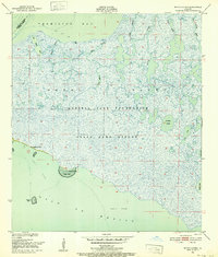
1946 Map of Redfish Point NE
USGS Topo · Published 1946About this map
Vermilion Bay dominates this coastal survey, where the marshes of southern Louisiana meet the Gulf waters. This 1946 advance sheet, compiled from Air Corps aerial photography, documents the intricate shoreline and swampy terrain of the Redfish Point Quadrangle. Navigational landmarks are sparse but critical in this maritime landscape, anchored by the Redfish Lighthouse at Redfish Point. The map provides a precise record of the shoreline before decades of coastal erosion altered the marshy fringes of North Lake and Indian Point. Further east along the marsh edge, the label Muddy suggests the difficult, saturated character of the land at the bay's edge, highlighting the challenges faced by the U.S. Geological Survey field examiners in 1932.
Find a feature on this map
6 named features on this map. Tap any name to fly to it.
Don’t see what you’re looking for? This feature index may not catch every label — zoom into the map to look around manually.
Map Details
Editions of this 1946 Redfish Point NE Map
This is the sole edition of this map. No revisions or reprints were ever made.
Other maps of this area

1932 · Abbeville SW
USGS Topo · 1:31,680

1932 · Abbeville SE
USGS Topo · 1:31,680

1937 · Derouen
USGS Topo · 1:62,500

1945 · New Orleans
USGS Topo · 1:250,000

1946 · Redfish Point SW
USGS Topo · 1:31,680

1946 · Redfish Point SE
USGS Topo · 1:31,680

1946 · Redfish Point NW
USGS Topo · 1:31,680

1948 · Cypremort Point
USGS Topo · 1:24,000

1949 · Bayou Lucien
USGS Topo · 1:31,680
1951 · Bayou Lucien
USGS Topo · 1:24,000