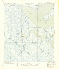
1954 Map of Redfish Point NW
USGS Topo · Published 1954About this map
Belle Isle and the vast marshlands of the Gulf Coast dominate this mid-century survey of the Vermilion Parish coastline. A complex network of natural waterways like Coles Bayou and Deep Bayou interlace with man-made features such as the Methelinny Canal and the Belle Isle Canal, illustrating the early efforts to navigate and manage this aquatic landscape. At the heart of the marsh, Gordon Camp Audubon stands as a rare named outpost of human activity amidst the wetlands.
Find a feature on this map
27 named features on this map. Tap any name to fly to it.
Don’t see what you’re looking for? This feature index may not catch every label — zoom into the map to look around manually.
Map Details
Editions of this 1954 Redfish Point NW Map
This is the sole edition of this map. No revisions or reprints were ever made.
Other maps of this area

1932 · Abbeville SW
USGS Topo · 1:31,680

1932 · Abbeville SE
USGS Topo · 1:31,680

1932 · Pecan Island SE
USGS Topo · 1:31,680

1945 · Pecan Island NE
USGS Topo · 1:31,680

1946 · Redfish Point SW
USGS Topo · 1:31,680

1946 · Schooner Bayou SE
USGS Topo · 1:31,680

1946 · Redfish Point NE
USGS Topo · 1:31,680

1946 · Redfish Point SE
USGS Topo · 1:31,680

1946 · Redfish Point NW
USGS Topo · 1:31,680

1951 · Pecan Island
USGS Topo · 1:62,500