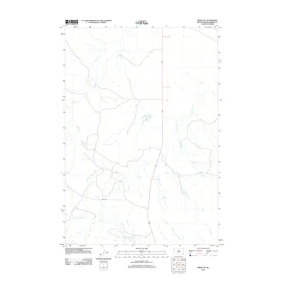
2012 Map of Redig NE
USGS Topo · Published 2012About this map
The N Fork Moreau River system defines this corner of Harding County, South Dakota, as it appeared in the early 21st century. The landscape is marked by the dendritic patterns of high-plains watercourses, including Clarks Fork Cr and Buffalo Cr. These drainage networks have long dictated the movement of livestock and the placement of transportation routes in this open ranching country. Local infrastructure is represented by rural thoroughfares such as Mackey Rd and J B Rd, which provide access through the vast grazing lands between the river and eastern drainages like S Br Duck Cr and Duck Cr. This 2012 survey illustrates the sparse but critical network of roads and waterways that support the agricultural economy of the northern Great Plains.
Find a feature on this map
7 named features on this map. Tap any name to fly to it.
Don’t see what you’re looking for? This feature index may not catch every label — zoom into the map to look around manually.
Map Details
Editions of this 2012 Redig NE Map
This is the sole edition of this map. No revisions or reprints were ever made.
Other maps of this area

1935 · Reva
USGS Topo · 1:125,000

1935 · Hoover
USGS Topo · 1:125,000

1935 · Harding
USGS Topo · 1:125,000

1935 · Buffalo
USGS Topo · 1:125,000

1954 · Lemmon
USGS Topo · 1:250,000

1957 · Lemmon
USGS Topo · 1:250,000

1971 · Buffalo
USGS Topo · 1:24,000
1971 · Sheep Pen Draw SW
USGS Topo · 1:24,000

1971 · Saddle Butte
USGS Topo · 1:24,000

1973 · Bog Creek
USGS Topo · 1:24,000