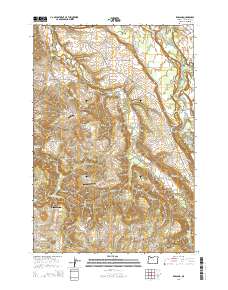
2014 Map of Redland
USGS Topo · Published 2014About this map
Redland and its surrounding rural communities in Clackamas County are captured here in the early twenty-first century, showing a landscape defined by the winding course of Clear Cr and the Clackamas River. For genealogists and local historians, the area is rich with family-named landmarks and several distinct burial grounds, including the Redland Cem, Viola Cem, and Moehnke Cem. The map illustrates a transitional geography between the more settled areas near Beavercreek and the rising terrain of The Hogback and North Highland. Small-scale aviation is represented by facilities like the Parson Landing Airport and Skyhill Airport, while recreation is centered on the river at Paradise Park and the Feldheimer Boat Ramp. The density of named rural roads, such as S Fischers Mill Rd and S Redland Rd, provides a precise framework for tracing property boundaries and historic homestead locations throughout this portion of the Pacific Northwest.
Find a feature on this map
109 named features on this map. Tap any name to fly to it.
Don’t see what you’re looking for? This feature index may not catch every label — zoom into the map to look around manually.
Map Details
Editions of this 2014 Redland Map
This is the sole edition of this map. No revisions or reprints were ever made.
Other maps of this area

1911 · Boring
USGS Topo · 1:48,000

1914 · Boring
USGS Topo · 1:62,500

1914 · Oregon City
USGS Topo · 1:62,500

1916 · Estacada
USGS Topo · 1:125,000

1939 · Molalla
USGS Topo · 1:62,500

1939 · Oregon City
USGS Topo · 1:62,500

1940 · Molalla
USGS Topo · 1:62,500

1940 · Boring
USGS Topo · 1:62,500

1941 · Oregon City
USGS Topo · 1:62,500

1948 · Vancouver
USGS Topo · 1:250,000