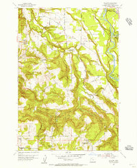
1954 Map of Redland
USGS Topo · Published 1956About this map
Clackamas River bends through the eastern portion of this quadrangle, serving as a focal point for local industry and recreation during the mid-1950s. The site of Feldheimer Ferry remains a visible marker of earlier river crossings, while nearby Bonnie Lure Park and Paradise Park highlight the area's transition into a space for public leisure. The interior landscape is defined by the winding course of Clear Creek and its many tributaries, such as Little Clear Creek and Mosier Creek, which carve through the terrain near the ridge known as The Hogback.
Find a feature on this map
43 named features on this map. Tap any name to fly to it.
Don’t see what you’re looking for? This feature index may not catch every label — zoom into the map to look around manually.
Map Details
Editions of this 1954 Redland Map
This is the sole edition of this map. No revisions or reprints were ever made.
Other maps of this area

1911 · Boring
USGS Topo · 1:48,000

1914 · Boring
USGS Topo · 1:62,500

1914 · Oregon City
USGS Topo · 1:62,500

1916 · Estacada
USGS Topo · 1:125,000

1939 · Molalla
USGS Topo · 1:62,500

1939 · Oregon City
USGS Topo · 1:62,500

1940 · Molalla
USGS Topo · 1:62,500

1940 · Boring
USGS Topo · 1:62,500

1941 · Oregon City
USGS Topo · 1:62,500

1948 · Vancouver
USGS Topo · 1:250,000