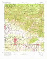
1954 Map of Redlands
USGS Topo · Published 1973About this map
The San Bernardino Mountains dominate the northern half of this mid-century landscape, transitioning from the high-elevation settlements along Rim of the World Drive down to the citrus groves and urban centers of the valley. The map reveals the post-war expansion of Redlands, showcasing the campus of the University of Redlands and the historic San Gabriel Mission Asistencia. In the valley, Norton Air Force Base stands as a significant military installation near Highland, while the presence of the Patton State Hospital and numerous local schools like the Mission Sch and Cram Sch reflect a growing civic infrastructure. The transport network is defined by the Atchison Topeka and Santa Fe and Southern Pacific railroads, which facilitated the region's agricultural economy. From the mountain retreats of Skyforest and Running Springs to the burgeoning residential grids of Yucaipa, this survey captures the county in a period of significant development.
Find a feature on this map
92 named features on this map. Tap any name to fly to it.
Don’t see what you’re looking for? This feature index may not catch every label — zoom into the map to look around manually.
Map Details
Editions of this 1954 Redlands Map
3 editions found
Other maps of this area

1896 · San Bernardino
USGS Topo · 1:62,500

1898 · San Bernardino
USGS Topo · 1:62,500

1899 · Redlands
USGS Topo · 1:62,500

1901 · Southern California Sheet No. 1
USGS Topo · 1:250,000

1901 · San Jacinto
USGS Topo · 1:125,000

1901 · San Bernardino
USGS Topo · 1:62,500

1901 · Redlands
USGS Topo · 1:62,500

1901 · Elsinore
USGS Topo · 1:125,000

1901 · Riverside
USGS Topo · 1:62,500

1902 · Deep Creek
USGS Topo · 1:62,500