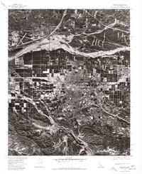
1975 Map of Redlands
USGS Topo · Published 1977About this map
Redlands is captured here during a period of significant mid-1970s development, shown through the detailed lens of an orthophotograph. The aerial perspective reveals a striking contrast between the organized city grid and the expansive, braided terrain of the Santa Ana Wash to the north. To the northwest, the strategic footprint of Norton Air Force Base is clearly visible, highlighting the region's historical military importance. The southern portion of the map is defined by the winding route of San Timoteo Canyon, where the natural topography begins to rise sharply away from the valley floor. This survey provides a rare visual record of the land use patterns during the 1970s, documenting how the built environment was increasingly encroaching upon the alluvial landscapes and traditional citrus groves typical of the San Bernardino Valley.
Find a feature on this map
5 named features on this map. Tap any name to fly to it.
Don’t see what you’re looking for? This feature index may not catch every label — zoom into the map to look around manually.
Map Details
Editions of this 1975 Redlands Map
This is the sole edition of this map. No revisions or reprints were ever made.
Other maps of this area

1896 · San Bernardino
USGS Topo · 1:62,500

1898 · San Bernardino
USGS Topo · 1:62,500

1899 · Redlands
USGS Topo · 1:62,500

1901 · Southern California Sheet No. 1
USGS Topo · 1:250,000

1901 · San Bernardino
USGS Topo · 1:62,500

1901 · Redlands
USGS Topo · 1:62,500

1901 · Elsinore
USGS Topo · 1:125,000

1901 · Riverside
USGS Topo · 1:62,500

1904 · Southern California Sheet No. 1
USGS Topo · 1:250,000

1936 · Arrowhead
USGS Topo · 1:31,680