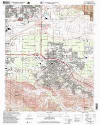
1996 Map of Redlands
USGS Topo · Published 1999About this map
Redlands and its surrounding communities are documented here during a period of significant suburban integration and infrastructure development. The city center is densely detailed with landmarks such as the Armory, City Hall, and numerous educational institutions like Redlands High School and the Smiley School. To the west, the historic San Bernardino Asistencia stands near Bryn Mawr, while the northern reaches are dominated by the San Bernardino International Airport and the sprawling Santa Ana Wash. The landscape is a complex grid of citrus-named avenues like Citrus Ave and Orange Ave, reflecting the area's agricultural heritage even as residential tracts expand toward the San Bernardino National Forest. Traces of the region's transport history are visible along the Southern Pacific rail line and the historic Mission Zanja waterway, which cuts through the heart of the settlement.
Find a feature on this map
87 named features on this map. Tap any name to fly to it.
Don’t see what you’re looking for? This feature index may not catch every label — zoom into the map to look around manually.
Map Details
Editions of this 1996 Redlands Map
This is the sole edition of this map. No revisions or reprints were ever made.
Other maps of this area

1896 · San Bernardino
USGS Topo · 1:62,500

1898 · San Bernardino
USGS Topo · 1:62,500

1899 · Redlands
USGS Topo · 1:62,500

1901 · Southern California Sheet No. 1
USGS Topo · 1:250,000

1901 · San Bernardino
USGS Topo · 1:62,500

1901 · Redlands
USGS Topo · 1:62,500

1901 · Elsinore
USGS Topo · 1:125,000

1901 · Riverside
USGS Topo · 1:62,500

1904 · Southern California Sheet No. 1
USGS Topo · 1:250,000

1936 · Arrowhead
USGS Topo · 1:31,680