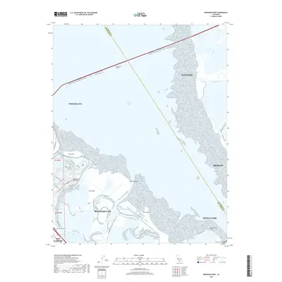
2018 Map of Redwood Point
USGS Topo · Published 2018About this map
San Francisco Bay dominates this map, serving as the central divide between the coastal developments of the San Francisco Peninsula and the eastern shores of the South Bay. The map illustrates the complex network of tidal wetlands and marshy archipelagos, including the expansive Bair Island, Greco Island, and Bird Island. These landforms are separated by a serpentine system of waterways such as Steinberger Slough and Westpoint Slough. Modern transit infrastructure spans the water, with the San Mateo Bridge cutting across the northern bay and the Dumbarton Bridge visible at the southern edge. Along the western shore, the residential and commercial footprints of Redwood City and Foster City are clearly delineated, including the specific street grids near San Carlos Airport. To the east, the map traces the recreational and environmental corridors of the Alameda Creek Trail and Shoreline Trail as they navigate the fringe of Hayward and Fremont.
Find a feature on this map
42 named features on this map. Tap any name to fly to it.
Don’t see what you’re looking for? This feature index may not catch every label — zoom into the map to look around manually.
Map Details
Editions of this 2018 Redwood Point Map
This is the sole edition of this map. No revisions or reprints were ever made.
Other maps of this area

1892 · San Mateo
USGS Topo · 1:62,500

1896 · San Mateo
USGS Topo · 1:62,500

1897 · Palo Alto
USGS Topo · 1:62,500

1899 · Palo Alto
USGS Topo · 1:62,500

1899 · Haywards
USGS Topo · 1:62,500

1899 · San Mateo
USGS Topo · 1:62,500

1902 · Santa Cruz
USGS Topo · 1:125,000

1915 · San Mateo
USGS Topo · 1:62,500

1915 · Haywards
USGS Topo · 1:62,500

1939 · San Mateo
USGS Topo · 1:62,500