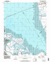
1993 Map of Redwood Point
USGS Topo · Published 1997About this map
San Francisco Bay dominates this 1993 study of the south bay's industrial and natural shoreline. The landscape is defined by the complex interface of land and water, featuring extensive salt evaporators and tidal marshlands surrounding Bair Island and Greco Island. The Port of Redwood City serves as a critical maritime hub, with the deep-water channels of Redwood Creek and Westpoint Slough providing access for shipping. Rapid late-century development is visible in the structured residential grids of Foster City and Redwood City, contrasted against the remnants of the salt industry that historically shaped these shores. Major infrastructure like the San Mateo Bridge (Toll) and the Dumbarton Bridge frame the transit corridors connecting the peninsula to Alameda County across the expansive mud flats of the bay floor.
Find a feature on this map
35 named features on this map. Tap any name to fly to it.
Don’t see what you’re looking for? This feature index may not catch every label — zoom into the map to look around manually.
Map Details
Editions of this 1993 Redwood Point Map
This is the sole edition of this map. No revisions or reprints were ever made.
Other maps of this area

1892 · San Mateo
USGS Topo · 1:62,500

1896 · San Mateo
USGS Topo · 1:62,500

1897 · Palo Alto
USGS Topo · 1:62,500

1899 · Palo Alto
USGS Topo · 1:62,500

1899 · Haywards
USGS Topo · 1:62,500

1899 · San Mateo
USGS Topo · 1:62,500

1902 · Santa Cruz
USGS Topo · 1:125,000

1915 · San Mateo
USGS Topo · 1:62,500

1915 · Haywards
USGS Topo · 1:62,500

1939 · San Mateo
USGS Topo · 1:62,500