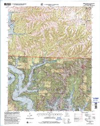
1999 Map of Reeds Spring
USGS Topo · Published 2002About this map
Table Rock Lake dominates the southern half of this landscape, its winding arms reaching into narrow Ozark valleys such as Coon Creek Hollow and Hodge Hollow. The shoreline is heavily developed for recreation, featuring the Highway 13 Campground and Aunts Creek Public Use Area, reflecting the region's late-century shift toward tourism and leisure. To the north, the terrain rises into the ridges of Wolf Ridge and the Mark Twain National Forest. Local history is anchored by family-named landmarks and rural institutions, including Shepherd Cem and Maranatha Ch. The presence of Talking Rocks Cavern and Emerson Airport illustrates the diverse land use, while the community of Kimberling City serves as a primary hub along the water's edge.
Find a feature on this map
48 named features on this map. Tap any name to fly to it.
Don’t see what you’re looking for? This feature index may not catch every label — zoom into the map to look around manually.
Map Details
Editions of this 1999 Reeds Spring Map
This is the sole edition of this map. No revisions or reprints were ever made.
Other maps of this area

1907 · Forsyth
USGS Topo · 1:125,000

1927 · Shell Knob
USGS Topo · 1:62,500

1942 · Aurora
USGS Topo · 1:62,500

1945 · Harrison
USGS Topo · 1:250,000

1945 · Aurora
USGS Topo · 1:62,500

1949 · Harrison
USGS Topo · 1:250,000

1950 · Shell Knob
USGS Topo · 1:62,500

1950 · Garber
USGS Topo · 1:24,000

1954 · Harrison
USGS Topo · 1:250,000

1956 · Lampe
USGS Topo · 1:24,000