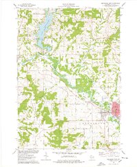
1975 Map of Reedsburg West
USGS Topo · Published 1978About this map
Lake Redstone dominates the northern landscape of this mid-1970s survey, its winding shoreline creating a central focus for recreation and early residential development at Lake Redstone County Park. The Baraboo River carves a path through the center of the sheet, followed closely by the Chicago and North Western railway, which connects the primary settlements of La Valle and Reedsburg. This transportation corridor highlights the region's movement from agricultural reliance toward industrial hubs, evidenced by the Industrial Waste Ponds and the cluster of civic and educational buildings in Reedsburg, such as City Hall, Webb High Sch, and St Peters Sch. Away from the river valley, the terrain rises toward heights like Thieman Hill and Lighthouse Rock, while rural life is marked by numerous family and community landmarks including St Patricks Cem, Babb Cem, and Resting Green Cemetery.
Find a feature on this map
57 named features on this map. Tap any name to fly to it.
Don’t see what you’re looking for? This feature index may not catch every label — zoom into the map to look around manually.
Map Details
Editions of this 1975 Reedsburg West Map
This is the sole edition of this map. No revisions or reprints were ever made.
Other maps of this area

1901 · Denzer
USGS Topo · 1:62,500

1901 · The Dells
USGS Topo · 1:62,500

1905 · Richland Center
USGS Topo · 1:125,000

1956 · Reedsburg
USGS Topo · 1:62,500

1957 · Wisconsin Dells
USGS Topo · 1:62,500

1957 · Madison
USGS Topo · 1:250,000

1958 · North Freedom
USGS Topo · 1:62,500

1958 · La Crosse
USGS Topo · 1:250,000

1960 · Madison
USGS Topo · 1:250,000

1960 · Plain
USGS Topo · 1:62,500