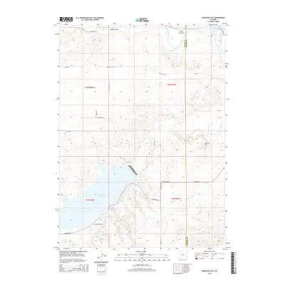
2015 Map of Register Cliff
USGS Topo · Published 2015About this map
Register Cliff stands as the prominent landmark along the northern edge of this high-plains landscape, where the North Platte River and Laramie River converge near the Platte Co Goshen Co line. This survey captures a modern view of a corridor deeply tied to westward expansion, with the White Rock Trce winding through the terrain. The southern portion of the quadrangle is dominated by the sprawling waters of Grayrocks Reservoir, an engineered landscape that contrasts with the natural drainages of Sixmile Cr and Little Deer Cr. Elevated features like Mummy Mtn provide a vertical perspective on the surrounding Bettelyoun Flats. The network of rural routes, including S Guernsey Rd and Fort Laramie Rd, connects these waters and terrain features, outlining the contemporary geography of these historic southeastern Wyoming ranchlands.
Find a feature on this map
28 named features on this map. Tap any name to fly to it.
Don’t see what you’re looking for? This feature index may not catch every label — zoom into the map to look around manually.
Map Details
Editions of this 2015 Register Cliff Map
This is the sole edition of this map. No revisions or reprints were ever made.
Other maps of this area

1896 · Hartville
USGS Topo · 1:125,000

1901 · Hartville
USGS Topo · 1:125,000

1950 · Rockeagle
USGS Topo · 1:24,000

1950 · Guernsey
USGS Topo · 1:24,000

1950 · Casebier Hill
USGS Topo · 1:24,000

1950 · Fort Laramie
USGS Topo · 1:24,000

1950 · Register Cliff
USGS Topo · 1:24,000

1950 · Guernsey Reservoir
USGS Topo · 1:24,000

1951 · Guernsey Reservoir
USGS Topo · 1:24,000

1951 · Antelope Gap
USGS Topo · 1:24,000