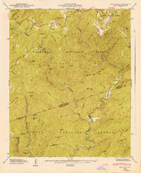
1947 Map of Reid
USGS Topo · Published 1947About this map
Toxaway Falls and the waters of Lake Toxaway define the upper reaches of this 1947 survey, where the steep terrain of the Blue Ridge meets the state border. This landscape is a complex intersection of three major protected areas: Pisgah National Forest, Nantahalha National Forest, and Sumter National Forest. Small settlements such as Oakland and Reid are connected by the Bearwallow Road, while the southern portion of the map transitions into the river valleys of the Toxaway River and Whitewater River.
Find a feature on this map
64 named features on this map. Tap any name to fly to it.
Don’t see what you’re looking for? This feature index may not catch every label — zoom into the map to look around manually.
Map Details
Editions of this 1947 Reid Map
This is the sole edition of this map. No revisions or reprints were ever made.
Other maps of this area

1886 · Walhalla
USGS Topo · 1:125,000

1888 · Pickens
USGS Topo · 1:125,000

1891 · Cowee
USGS Topo · 1:125,000

1892 · Walhalla
USGS Topo · 1:125,000

1894 · Pickens
USGS Topo · 1:125,000

1896 · Walhalla
USGS Topo · 1:125,000

1897 · Cowee
USGS Topo · 1:125,000

1905 · Pisgah
USGS Topo · 1:125,000

1906 · Pisgah
USGS Topo · 1:125,000

1907 · Cowee
USGS Topo · 1:125,000