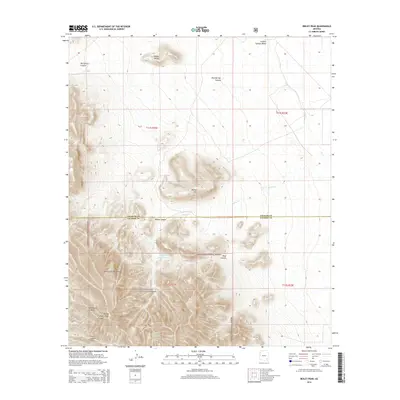
2014 Map of Reiley Peak
USGS Topo · Published 2014About this map
The Winchester Mountains dominate this high-desert landscape in southeastern Arizona, straddling the border of Graham and Cochise counties. Much of the southern portion of the map is protected within the Coronado National Forest, where steep drainages like Rockhouse Canyon and Rose Canyon cut through the rugged terrain. The topography transitions from these sharp peaks down toward the Sulphur Springs Valley to the northeast. Water management in this arid environment is evidenced by the Upper Reiley Tank and scattered water sources such as Mud Springs and Bear Spring. Notable landmarks such as Hooker Butte and Reiley Hill provide distinct navigational points for those tracing the historical geography of this ranching and forest region, where Reiley Creek and Ash Creek provide the primary drainage routes for the mountain runoff.
Find a feature on this map
22 named features on this map. Tap any name to fly to it.
Don’t see what you’re looking for? This feature index may not catch every label — zoom into the map to look around manually.
Map Details
Editions of this 2014 Reiley Peak Map
This is the sole edition of this map. No revisions or reprints were ever made.
Other maps of this area

1922 · Willcox
USGS Topo · 1:125,000

1940 · Sierra Bonita Ranch
USGS Topo · 1:62,500

1942 · Sierra Bonita Ranch
USGS Topo · 1:62,500

1942 · Mt. Graham
USGS Topo · 1:62,500

1943 · Willcox
USGS Topo · 1:62,500

1943 · Sierra Bonita Ranch
USGS Topo · 1:62,500

1943 · Winchester Mts.
USGS Topo · 1:62,500

1945 · Mt. Graham
USGS Topo · 1:62,500

1945 · Winchester Mts.
USGS Topo · 1:62,500

1954 · Silver City
USGS Topo · 1:250,000