1947 Map of Relay
USGS Topo · Published 1954About this map
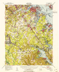
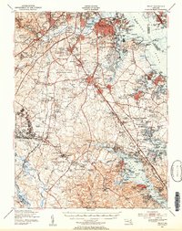
Industrial and aviation development defines the suburban landscape south of Baltimore City in the late 1940s. The massive footprint of the Baltimore Friendship International Airport dominates the central terrain, while to the south, the Fort George G Meade Military Reservation and the U S Naval Academy Dairy mark significant federal land use. Along the shoreline, established maritime communities like Masonville and Fairfield sit near Curtis Bay, providing a view of the region's shipping and industrial roots before mid-century expansion.
Find a feature on this map
205 named features on this map. Tap any name to fly to it.
Don’t see what you’re looking for? This feature index may not catch every label — zoom into the map to look around manually.
Map Details
Editions of this 1947 Relay Map
2 editions found
Other maps of this area

1892 · Laurel
USGS Topo · 1:62,500

1892 · Ellicott
USGS Topo · 1:62,500

1892 · Owensville
USGS Topo · 1:62,500

1892 · Annapolis
USGS Topo · 1:62,500

1893 · North Point
USGS Topo · 1:62,500

1893 · Gunpowder
USGS Topo · 1:62,500

1894 · Ellicott
USGS Topo · 1:62,500

1894 · Laurel
USGS Topo · 1:62,500

1894 · Baltimore
USGS Topo · 1:62,500

1894 · Relay
USGS Topo · 1:62,500