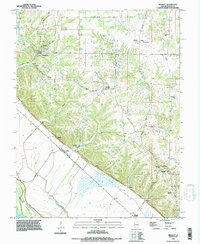
1993 Map of Renault
USGS Topo · Published 1996About this map
Maeystown and Renault anchor this landscape where the high prairie meets the lowlands of the Mississippi River. The terrain is defined by a dramatic bluff line that separates upland features like Bushy Prairie and Morrison Hollow from the bottomlands near Fults. Subsurface complexity is evident through several named caverns, including Saltpeter Cave, Mammoth Cave, and Fogelpole Cave, suggesting the karst topography of Monroe County. Genealogists can find several local burial grounds, such as Dick Cemetery, Grant Pass Cemetery, and Studt Cemetery. The drainage patterns are particularly intricate, showing Old Maeystown Creek winding toward Beagles Island and a series of drainage structures like the Ditch near Renault (Station), illustrating the intensive water management required in this river-border region.
Find a feature on this map
42 named features on this map. Tap any name to fly to it.
Don’t see what you’re looking for? This feature index may not catch every label — zoom into the map to look around manually.
Map Details
Editions of this 1993 Renault Map
This is the sole edition of this map. No revisions or reprints were ever made.
Other maps of this area

1910 · Waterloo
USGS Topo · 1:62,500

1912 · Kimmswick
USGS Topo · 1:62,500

1913 · Waterloo
USGS Topo · 1:62,500

1915 · Renault
USGS Topo · 1:62,500

1915 · Crystal City
USGS Topo · 1:62,500

1916 · Kimmswick
USGS Topo · 1:62,500

1940 · Renault
USGS Topo · 1:62,500

1948 · Kimmswick
USGS Topo · 1:62,500

1949 · Saint Louis
USGS Topo · 1:250,000

1949 · Crystal City
USGS Topo · 1:62,500