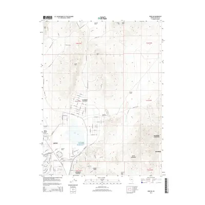
2014 Map of Reno NE
USGS Topo · Published 2014About this map
Swan Lake sits at the heart of this high-desert basin, where the suburban fringes of northern Reno meet the vast interior ranges of Washoe County. This 2014 survey captures a period of significant residential expansion as neighborhoods like Lemmon Valley, Golden Valley, and Sun Valley push toward the surrounding peaks. The landscape is defined by its topographic extremes, from the flat drainage of Antelope Valley to the prominent heights of Freds Mtn and the Hungry Range. Transportation and aviation history are evident in the presence of the Reno-Stead Airport and the smaller Youngberg Ranch Airport, which emphasize the area's role as a regional hub. The map provides an intricate look at local infrastructure, detailing a dense network of residential streets such as Deodar Way and Heartpine St that mark the evolving footprint of Sparks and Spanish Springs.
Find a feature on this map
99 named features on this map. Tap any name to fly to it.
Don’t see what you’re looking for? This feature index may not catch every label — zoom into the map to look around manually.
Map Details
Editions of this 2014 Reno NE Map
This is the sole edition of this map. No revisions or reprints were ever made.
Other maps of this area

1891 · Reno
USGS Topo · 1:125,000

1893 · Reno
USGS Topo · 1:125,000

1950 · Reno
USGS Topo · 1:62,500

1951 · Reno
USGS Topo · 1:62,500

1957 · Sutcliffe
USGS Topo · 1:62,500
1957 · Vista
USGS Topo · 1:24,000

1957 · Dogskin Mountain
USGS Topo · 1:62,500

1957 · Spanish Springs Valley
USGS Topo · 1:62,500

1957 · Reno
USGS Topo · 1:250,000

1959 · Reno
USGS Topo · 1:250,000