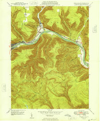
1948 Map of Renovo East
USGS Topo · Published 1948About this map
The West Branch Susquehanna River carves a deep valley through the northern Pennsylvania mountains, anchoring a string of rail-dependent settlements in the late 1940s. The town of Renovo and its counterpart South Renovo serve as the primary hubs, where the Pennsylvania RR follows the narrow riverside bench alongside the historic Bucktail Trail. To the east, the landscape transitions into the steep drainages of Noyes and Chapman townships, where small clusters like Gleasonton and North Bend sit at the mouths of rugged hollows. This survey reveals the area's industrial and transport foundations, from the Hyner Landing Field to the numerous family-named landmarks like McCloskey Island and McCloskey Run that speak to the long history of land ownership in this river-and-rail corridor.
Find a feature on this map
45 named features on this map. Tap any name to fly to it.
Don’t see what you’re looking for? This feature index may not catch every label — zoom into the map to look around manually.
Map Details
Editions of this 1948 Renovo East Map
This is the sole edition of this map. No revisions or reprints were ever made.
Other maps of this area

1921 · Howard
USGS Topo · 1:48,000

1923 · Howard
USGS Topo · 1:62,500

1928 · Snow Shoe
USGS Topo · 1:48,000

1931 · Show Shoe
USGS Topo · 1:62,500

1943 · Hyner
USGS Topo · 1:62,500

1946 · Young Womans Creek
USGS Topo · 1:24,000

1946 · Renovo East
USGS Topo · 1:62,500

1946 · Renovo West
USGS Topo · 1:62,500

1946 · Tamarack
USGS Topo · 1:24,000

1946 · Slate Run
USGS Topo · 1:24,000
Featured Places
- South Renovo, PA
- Gleasonton, Chapman Township
- Noyes Township, PA
- Grugan Township, PA
- North Bend, Chapman Township